
LAZY SURVEYOR
Win64, EnglishGeneral Usage Instructions
-
RUN lazy_import to import point coordinates from txt, sdr, gsi, or csv formats. Set text height, point size, color, and rotation, or use defaults. Choose to import point code and elevation; points are numbered by default.
-
RUN lazy_export to export data from AutoCAD to selected file types. Set text height, point size, color, and rotation, or use defaults. Export methods include picking points, selecting polylines (with/without offsets), and exporting to SDR, txt, or GSI formats. Optionally create an Excel report or AutoCAD table report.
-
RUN lazy_convertor for converting between sdr, gsi, txt, csv, and dxf. Select the input file type for a data view, then export to your desired format.
-
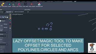
RUN LAZY_OFFSET to select Polylines, Circles, or Arcs. Enter offset value, choose inside/outside for placement, and select color for the new objects, which will be drawn.
-
RUN LAZY_CENTER to select closed objects, specify point size, and draw points at the object's center.
-
RUN LAZY_AREA to select closed objects and pick a location for area text.
-
RUN LAZY_LENGTH to select the object type and designate where to place the length text.
-
RUN LAZY_INTERSECTION to select objects and draw points at their intersections.
-
RUN TABLE to create a table with coordinates.
-
Use LABEL to write coordinate labels beside the points.
-
Use average to write the Average of selected points.
Screenshots


Commands
| Ribbon/Toolbar Icon | Command | Command Description |
|---|---|---|

|
ls_import |
Import data to AutoCAD |

|
ls_export |
Export data from AutoCAD |

|
ls_convertor |
converter between varial types of data (sdr-gsi-txt-csv-dxf) |

|
ls_leader |
Leader with coordinates, AREA AND LENGTH |

|
ls_offset |
Offset selected polylines, circles and arcs |

|
ls_center |
Draw point at center of closed objects |

|
ls_area |
Get the area of selected objects |

|
ls_length |
Get the length of selected objects |

|
ls_intersection |
Draw points at the intersection of objects |

|
ls_table |
create table for picked places or selected points |

|
ls_average |
get average level of selected points or blocks and make report |

|
ls_lable |
make coordinate label for selected points with or without leader |
Installation/Uninstallation
The installer that ran when you downloaded this app/plug-in from the Autodesk App Store will start installing the app/plug-in. or, simply double-click the downloaded installer to install the app/plugin. You may need to restart the Autodesk product to activate the app/plug-in. To uninstall this plug-in, exit the Autodesk product if you are currently running it, simply rerun the installer, and select the "Uninstall" button. or, click Control Panel > Programs > Programs and Features (Windows 7/8.1/10/11) and uninstall as you would any other application from your system.
Additional Information
Known Issues
Contact
Author/Company Information
Support Information
Contact: hshad1984@gmail.com
Version History
| Version Number | Version Description |
|---|---|
|
1.2.0 |
Improving the import and export process interface Adding other methods for data extraction Adding a table tool to extract coordinates within a table Adding a label tool to write coordinates next to points Adding an average tool to calculate points averages |
|
1.0 |
import/export data between AutoCAD and total station txt/sdr/gsi formats. Convert data types, multi offset for polylines, circles, and arcs. LEADER WITH COORDINATES. calculate length and areas, |
